|
History of the Stone Bridge
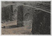
The Stone Bridge (also known as the Broad Run Bridge) stood for one hundred and fifty-six years over Broad Run, nine miles southeast of Leesburg on Route 7
(Leesburg Pike). The bridge featured a keystone arch construction with two 36-foot spans. It was built in 1820 to accommodate travelers from Alexandria to the Shenandoah Valley. The Stone Bridge was supposedly designed by Col. Claudius Crozet, who built the bridge over Broad Run while serving as a road engineer for the Virginia Board of Public Works. Crozet served in Napoleon s Army. He came to the U.S. in 1816, was a professor at West Point, and later established the School of Engineering at Virginia Military Institute (VMI). The bridge served traffic until Christmas Day 1949, when it was retired due to the opening of a steel bridge span.
On the south side of today's road is a stone Toll House. The original Toll House was one story and constructed with the bridge. (Later its structure was improved
and expanded to two stories.)
An Indian trail established this route of high ground through Fairfax and Loudoun Counties to the Blue Ridge Mountains. The trail was widened in the early 18th
century and became known as the Ridge Road. In those days, travelers crossed Broad Run by fording the stream. The first wooden bridge was built across Broad Run
prior to 1755. Since travel was heavy during this time, a typical early Virginia bridge was erected, composed of sleepers and rafters, boards that were laid at
right angles to the sleepers-usually without nails. If the bridge was flooded and needed its rafters adjusted or replaced, it was up to the next traveler who wished
to cross to repair the bridge. George Washington was probably one of those impromptu repairmen since it is known that he used the bridge in 1753 and 1754, when he
traveled to Fort Duquesne at the start of the French and Indian War. The Broad Run Bridge was one of the earliest county-maintained byways. As early as 1771,
minutes from Loudoun government meetings indicate that about $500 had to be allocated to reconstruction of the bridge "at the usual place."
1
An act of Assembly in 1785 authorized a road where tolls would be collected. Tolls were charged according to the type of vehicle: a coach or four wheel carriage -
1 shilling; a two wheel chair or chaise - 8 pence; a wagon - 1 shilling and a cart - 8 pence.
Leesburg Court House orders of 1766 and 1798 appointed workmen "to disengage the trees and lumber lodged against the bridge."
2
Replacement wooden bridges were built
in 1771 (at a cost of 150 pounds sterling); and in 1784 (at a cost of 24,000 pounds of tobacco). In 1799, the third bridge to be built was supposed to be completed
by the early 1800s, but it was delayed; in 1803 there was still no bridge.
On February 3, 1809, the General Assembly passed an Act incorporating the Leesburg Turnpike Company for the purpose of improving the road between Leesburg and Little River Turnpike. In 1809, the bridge was part of the $41,450 state appropriation to build the twenty mile Leesburg Turnpike from Leesburg to Dranesville. This sum, incidentally, was the largest state road appropriation to date.
In 1810, the Virginia State Legislature authorized the sale of 1000 shares of stock to be sold at $150.00 a share in the Leesburg Turnpike Co. The road was advertised to be a right-of-way of 60 ft., 17 ft. to be covered with gravel or stone, with an additional 17 ft. to be cleared and kept in repair for use by horses and walkers. Toll gates were permitted every 5 miles. A partial listing of the tolls charged were as follows:
- Every score (20) of sheep or hogs, six cents
- Every score of cattle, 12 cents
- Each horse, mare, mule or gelding, 3 cents
- Two-wheeled riding carriages, 6 cents
- Four-wheeled riding carriages, 12 cents
- Carts or wagons with wheels not exceeding 4 diameter, 3 cents/animal
- ...
The turnpike was completed by 1817 through Broad Run, and Levi Whaley, who had founded a settlement called Broad Run around the bridge site, became Postmaster of
a new Post Office called Whaley s Store at Broad Run Crossing. Around 1810, Whaley bought 51 acres on "both sides of the turnpike along Broad Run"
3
from Henry B. Lee, the last of the area's "Virginia Lees." When the main road from Alexandria to Leesburg shifted north to its present Route 7 alignment in 1817, Whaley's Store, at the Broad Run bridge, supplanted Lanesville (at Claude Moore Park in Sterling) as the main post stop in the area. There was also a grist mill at
the site.
Loudoun County workers started bridge construction in 1818. They quarried blocks of dark brown sandstone from the Blue Ridge Mountains and transported them to the
site. Marks from chisels were visible on many of these sandstone blocks. The date 1820 was carved on one of them. (They may have also used local stone, as there is
a quarry behind the Toll House which is filled with water.) By 1822, the new road extended to Dranesville, a distance of fourteen miles.
By 1834 The Leesburg Turnpike Company found itself in debt due to decreased tolls and an increase in the cost of repairs. The flood of September 1843, which washed
away the bridge over Goose Creek, and the completion of the Chesapeake and Ohio Canal, combined to doom the company. At the beginning of the Civil War, the road was abandoned as a toll road.
During World War I, two locals, Lertie Holsinger and Amos Jenkins, sold homemade whiskey for $2/pint or $8 or $9/gallon. A favorite location for selling the bootleg
was the Broad Run Toll House, still standing west of the run and on the south side of Route 7. Before the tolls were removed in 1924, every motor vehicle and wagon crossing the bridge had to stop by the stone building.
The Leesburg Garden Club saved the bridge from demolition in 1945, when the new steel bridge was being constructed. The Virginia Department of Highways owned the bridge; the Toll House was privately owned. At the time, it would have cost approximately $5000.00 to perform maintenance and preservation activities on the Stone Bridge to keep it structurally sound. This was never done.
On December 2, 1969, The Stone Bridge and the Toll House were added to the Virginia Landmark Register, and on April 17, 1970, they were added to the National
Register of Historic Places.
On June 21, 1972, Hurricane Agnes covered Stone Bridge and the Toll House in a torrential flood. A 12-foot span of the bridge eroded during the flooding. On
February 19, 1976, Mrs. James Eberly, owner of the Toll House at the time, said that the second span of the Broad Run Bridge fell shortly after 5 pm, blocking
one channel in the stream below.
John G. Lewis, a local representative of the Virginia Historic Landmarks Commission, stated after Stone Bridge's collapse: "Thirty-one years of intentional neglect
by the Virginia Department of Highways and Transportation finally pays off for them [with] the total destruction of a highway engineering monument."
4
At the time of the bridge's collapse, Mr. Lewis was trying to get the Loudoun County Board of Supervisors to agree to take over the bridge after the Virginia Deptartment of Highways (now VDOT) made repairs. Today, there is nothing left of the bridge save the abutments on each side of Broad Run.
In 1945, the Leesburg Garden Club began a campaign to save Stone Bridge - a cause embraced by the Preservation Society of Loudoun County in 1972. By reflecting our National Society's historic preservation objectives, Virginia Daughters of the American Revolution memorialized an 1820 engineering landmark in a Chartering Ceremony for Stone Bridge Chapter.
Sources:
Citations:
1. Loudoun Times Mirror, February 26, 1976 edition; File 53-110, Thomas Balch Library, Leesburg, Virginia.
2. Broad Run Farms Web site; Area History page: <http://www.broadrunfarms.com/history.htm>.
3. Broad Run Farms Web site; Area History page: <http://www.broadrunfarms.com/history.htm>.
4. Loudoun Times Mirror, February 26, 1976 edition; File 53-110, Thomas Balch Library, Leesburg, Virginia.
The content contained herein does not necessarily represent the position of the NSDAR.
Hyperlinks to other sites are not the responsibility of the NSDAR, the state organizations, or individual DAR chapters
|